
China YILO Drones Still Orbit Gyirong Flood Zone Near Nepal Tibet Border
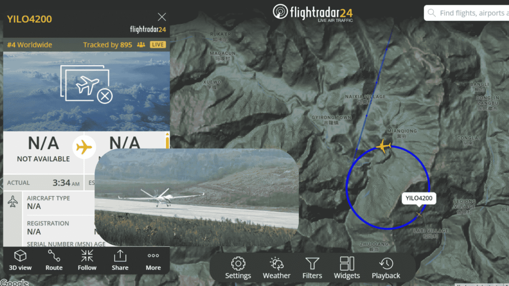
Three days after a catastrophic mudslide and flash flood devastated Gyirong Port on the China-Nepal border, two Chinese long-endurance drones tracked as YIL O4200 and YIL O4201 remained actively circling the disaster area in the early morning hours of August 29, 2026. Live Flightradar24 data showed both aircraft maintaining tight orbital patterns over the mountainous terrain near Gyirong Town, Mianqiong, Labi Village and surrounding settlements, drawing thousands of simultaneous trackers worldwide.
The continued presence of these platforms underlines the sustained aerial support role they are playing in one of the most difficult rescue operations the Himalayan region has seen in years. What began as an urgent response on August 26 has evolved into a multi-day effort involving persistent unmanned overwatch, communications relay, and real-time monitoring of secondary risks such as the barrier lake that formed upstream.
Table of Contents
The Scale of the Ongoing Disaster
The disaster was triggered by a high-altitude glacier collapse on the Nepalese side. The resulting ice avalanche rapidly transformed into a high-speed debris flow and mudslide that slammed into Gyirong Port around mid-morning on August 26. Buildings, vehicles, and infrastructure were swept away in minutes. Official figures as of early August 29 listed at least seven confirmed deaths on the Chinese side and more than 550 people still missing, including a large number of foreign nationals. On the Nepalese side the toll has been far higher, with hundreds confirmed dead and nearly two thousand missing.
Rescuers faced severe access problems. Roads were destroyed, power and communications were knocked out, and a newly formed barrier lake upstream posed the constant threat of a secondary flood. Professional teams only reached the core disaster zone late on August 28 after hiking through difficult terrain with ropes and inflatable boats. They reported finding little more than ruins.
In this environment, continuous aerial coverage becomes essential. Ground teams need updated imagery of shifting mud, water levels in the barrier lake, and possible signs of survivors. Commanders require reliable communications when terrestrial networks are down. That is precisely the role the YILO-series drones have been filling.
YILO4200 and YILO4201 on Station
Flightradar24 screenshots from the early hours of August 29 captured YILO4200 flying a clean circular orbit near Gyirong Town, ranked as the fourth most-tracked flight worldwide at the time. Shortly afterward, YILO4201 appeared in a denser, more complex pattern in the same airspace, rising to second place globally with more than 1,100 simultaneous trackers. Both aircraft showed the familiar “N/A” data fields typical of restricted Chinese military or dual-use platforms.
These call signs belong to the Wing Loong (Yilong) family of medium-altitude long-endurance UAVs produced by Chengdu Aircraft Corporation. Earlier in the response, state media confirmed that Wing Loong emergency-communications drones had been scrambled from Sichuan. One aircraft arrived over the disaster zone in the early hours of August 27 carrying high-definition cameras and mobile base stations from China’s three major telecom operators. Reports later indicated that two such UAVs had already logged more than 22 hours of continuous operation, supporting thousands of user connections and hundreds of emergency calls.
The fact that both YILO4200 and YILO4201 were still flying deliberate orbits days later suggests a deliberate rotation or dual-aircraft persistent-presence strategy. One platform can focus on wide-area reconnaissance and lake monitoring while the other maintains the communications bubble or concentrates sensors on the most critical search sectors.


Why Persistent Orbits Matter
High-altitude mountain valleys present unique challenges for both manned and unmanned aviation. Thin air reduces performance, weather can change in minutes, and the steep terrain limits safe approach routes. A long-endurance drone that can remain on station for many hours, transmitting live video and acting as a temporary cell tower, gives commanders a stable “eye in the sky” that helicopters and fixed-wing aircraft cannot match without constant refueling and crew changes.
Chinese officials have repeatedly highlighted the dual value of these systems. In addition to search and communications, the drones have been used for 3D mapping of the mud-covered zones and thermal scanning for possible heat signatures. Engineering teams monitoring the barrier lake have also relied on aerial data to assess whether the natural dam is stabilizing or still at high risk of breach.
One rescue coordinator involved in the operation described the contribution in practical terms: “When roads disappear and the ground itself is unstable, the continuous picture from above becomes the foundation for every decision on the ground.” Another official noted that the anti-icing systems and high-altitude performance of the Wing Loong platform allowed it to remain effective even when weather conditions grounded other assets.

Broader Context of High-Altitude UAV Capability
The sustained deployment over Gyirong is not an improvised response. China has spent recent years building specialized infrastructure for high-altitude unmanned systems, including the Plateau Drone R&D Application Centre at Xizang University and testing facilities in Ngari. Those investments were designed precisely for the kind of extreme environment now facing rescuers on the Nepal border. Lessons learned in thin air, cold temperatures, and complex terrain are being applied in real time.
Supporters of the program point to the clear humanitarian payoff. The same technology that can support border security and logistics is proving its worth when communities are cut off by natural disaster. The ability to restore communications, map unstable terrain, and keep eyes on secondary hazards such as barrier lakes directly saves time, and potentially lives, when every hour counts.
At the same time, the public visibility of the flights on platforms such as Flightradar24 has drawn global attention. Rankings in the top five most-tracked aircraft worldwide show that thousands of people are following the progress of the rescue effort through these open tracks. That transparency, even if limited by the “N/A” data fields, has become part of the information landscape surrounding the disaster.
Looking Ahead
As of August 29, rescue operations continue under difficult conditions. Additional rainfall is forecast, and the barrier lake remains under close watch. Professional search teams, military units, fire and rescue personnel, and engineering specialists are all working in the area. The continued presence of YILO4200 and YILO4201 indicates that unmanned systems will remain a core part of the response for as long as they are needed.
The story of these two drones is still unfolding. What began as an emergency scramble on August 26 has become a multi-day demonstration of persistent high-altitude unmanned capability in one of the world’s most challenging environments. For the teams on the ground at Gyirong, the circling orbits overhead represent more than technology, they represent a continuous link to the information and communications support required to keep searching.
For readers following the Tibet-Nepal border disaster, high-altitude UAV operations, or dual-use drone developments, the key development on August 29 is clear: YILO4200 and YILO4201 remain on station, maintaining the aerial watch that has supported rescue efforts since the first hours of the crisis.
You can also read about: China Deploys YILO4201 & YIL O4200 for Tibet Flood Rescue
Nepal Rasuwagadhi Flood Satellite Views
Last updated on August 29, 2026 at 6:46 am


