
China Deploys YILO4201 & YIL O4200 for Tibet Flood Rescue
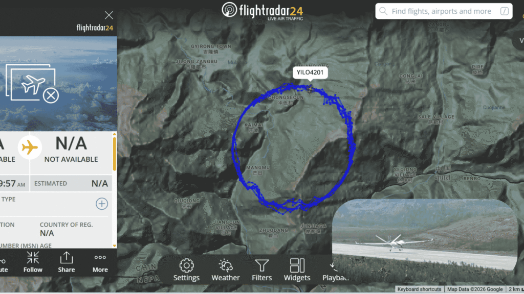
On August 26, 2026, a sudden mudslide and heavy flooding struck the Gyirong (Jilong) Port area along the China-Nepal border in Tibet’s Xizang Autonomous Region. The disaster hit the Nepalese side but spilled across into Chinese territory, cutting roads, threatening the port facilities, and leaving people missing. Within hours, Chinese authorities activated emergency response systems that included satellites and a large unmanned aerial vehicle tracked on Flightradar24 as YIL O4201 and YIL O4200.
Flight-tracking data captured YIL O4201 and YIL O4200 flying tight, continuous circles over the mountainous terrain near Gyirong Town, Chongsecun, Kaimai, and Mangmu villages. The track formed a clear orbit centered on the disaster zone, a classic pattern for persistent surveillance and communications support. Aircraft type, registration, and other details showed as unavailable on public trackers, typical for certain Chinese military or dual-use systems operating in sensitive border areas. The timing of the flight, beginning in the early morning hours of August 27 after the mudslide the previous day, aligned with official reports of a Wing Loong (Yilong) UAV arriving over the scene.
A photograph released by CCTV News shows a white, twin-boom Wing Loong-series drone on a runway in the highlands, consistent with the type of long-endurance platform associated with the YILO call-sign family. These aircraft are designed for extended loiter times, high-definition imaging, thermal detection, and the ability to carry temporary communications equipment, exactly the capabilities needed when ground access is blocked by mud, water, and unstable slopes.
Table of Contents
The Scale of the August 26 Disaster
Preliminary reports indicated at least three people dead and more than 260 missing in the immediate aftermath, with numbers still being verified as rescue teams pushed into the area. Rain continued, and a barrier lake formed upstream toward the Gyirong Port, raising the risk of further flooding. The mudslide edge sat only about 2.5 kilometers from the port, with debris roughly 1.5 meters thick in places. Traditional road access became nearly impossible, and the high altitude, combined with ongoing weather, complicated helicopter operations.
In response, the China National Space Administration coordinated satellite imaging, delivering both pre- and post-disaster pictures to emergency commanders. At the same time, a large Wing Loong UAV took off from Sichuan Province and reached the disaster area around 2 a.m. on August 27. Equipped with high-definition cameras, it conducted comprehensive reconnaissance. Critically, it also carried mobile base stations from China’s three major telecom operators plus a satellite communication system. This turned the drone into a temporary communications node, restoring links for rescue teams on the ground.
Smaller drones flew lower, building 3D real-scene models of the mud-covered zones and using thermal sensors to search for heat signatures of possible survivors in vegetation and debris. Tibetan military district units mobilized more than 150 personnel, engineering equipment, and specialized life-detection gear. The combination of satellite overwatch, the long-endurance YILO4201-type platform, and local short-range UAVs created a layered picture of the disaster that ground teams alone could not have achieved quickly.


Why a Long-Endurance Drone Matters in High-Altitude Floods
The Tibetan Plateau and the China-Nepal border valleys present unique challenges. Thin air reduces engine and battery performance. Cold temperatures and sudden weather changes test every system. Steep terrain and limited roads mean that when a mudslide or flood hits, entire communities can be cut off for days. A platform that can stay aloft for many hours, transmit live video, and act as a flying cell tower becomes a force multiplier.
YILO4201’s observed orbit over Gyirong matched the classic “persistent stare” pattern used for both disaster assessment and communications relay. By maintaining a circular track, the aircraft could keep sensors fixed on the most critical zones while remaining relatively stable against mountain winds. Officials noted that the drone provided stable imagery even in night-time low-visibility conditions—an important capability when rescue work continues around the clock.
One rescue coordinator described the early hours after the mudslide: teams on the ground needed reliable communications and a clear overall view before committing personnel into unstable mud. The arrival of the large UAV filled that gap. “In high-altitude, complex terrain, the drone gives us eyes and a voice when the roads disappear,” a local official was quoted as saying in state media coverage of similar past operations.
Dual-Use Technology in Action
The same family of aircraft has been refined through China’s recent investments in high-altitude UAV research. The Plateau Drone R&D Application Centre at Xizang University and the testing base in Ngari were established precisely to solve the technical problems of operating unmanned systems above 4,000 meters. Lessons learned from those facilities, engine performance in thin air, cold-weather battery management, and robust data links, directly benefit emergency responses like the one at Gyirong.
Supporters of the program emphasize the civilian payoff. In mountain regions, drones already help move supplies and remove waste on peaks such as Everest. When disaster strikes, the same platforms shift to search, mapping, and communications support. The August 26 response demonstrated that the technology is operational, not merely experimental. A large UAV flying from Sichuan to the Nepal border area in the middle of the night, carrying telecom equipment, and establishing a communications bubble is a concrete example of dual-use capability working under pressure.
External observers note that the border location adds a layer of sensitivity. Gyirong Port is a key crossing point. Any major natural disaster there affects both Chinese and Nepalese communities and the flow of people and goods. Rapid, transparent use of drones and satellites for life-saving purposes can reduce tension by focusing attention on shared humanitarian needs. At the same time, the ability to maintain persistent aerial coverage in a remote border valley inevitably has security implications, which Chinese statements frame as part of overall border management and emergency readiness.

Official Framing
Chinese state media highlighted the speed of the response. “Immediately after the disaster, satellite resources were coordinated for emergency imaging,” the China National Space Administration reported. The Wing Loong’s arrival in the early hours was presented as part of a coordinated effort that also included ground teams, search dogs, and specialized medical units airlifted into the region.
A military airlift pilot involved in related high-plateau missions earlier in the year captured the operational mindset: “When we learned our Tibetan compatriots were hit by disaster, we understood the mission was urgent and the responsibility heavy. We took off in the rain and landed safely at the high-altitude airfield.” Although that quote referred to a different event, it reflects the same institutional readiness that put YIL O4201 and YIL O4200 over Gyirong so quickly.
Local Tibetan authorities stressed the difficulty created by the barrier lake and continued rainfall. The drone’s ability to monitor the lake’s water level and the stability of the mudslide debris from a safe altitude reduced the need to send people into the most dangerous zones until conditions improved.
Broader Implications for Mountain Disaster Response
The August 26 deployment fits a larger pattern. China has increasingly treated the Tibetan Plateau as both a strategic frontier and a live laboratory for unmanned systems. Research centers, testing ranges, and operational experience feed one another. When a mudslide hits a remote border port, the systems refined for high-altitude flight are already available for immediate use.
For Nepal, the event underscores the shared vulnerability of Himalayan communities to extreme weather and geological hazards. Cross-border cooperation on disaster response, whether through information sharing or eventual joint use of aerial assets, could become more practical as both sides gain experience with the same class of technology. Commercial heavy-lift drones already operate on the Nepalese side of Everest; military and civil dual-use platforms on the Chinese side have now proven their value in an actual flood emergency only a short distance away.
Looking forward, the data collected by YIL O4201 and YIL O4200, the supporting satellite constellation will help refine models of mudslide risk in the Gyirong valley. Thermal search results, 3D terrain models, and communications performance logs all become inputs for the next generation of plateau-capable UAVs. In that sense, every emergency flight also advances the underlying technology.
For more on emerging tech’s societal impacts, subscribe to our newsletter.
Last updated on August 28, 2026 at 11:43 am


