Nepal Rasuwagadhi Flood Satellite Views
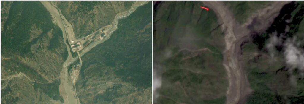
Satellite images of the Rasuwagadhi/Kerung border crossing reveal the stark transformation caused by the devastating flash flood that struck the Nepal-China border region in 26 August 2026. The side-by-side comparison, one frame showing the orderly infrastructure and river channels of the pre-flood landscape, the other capturing debris-choked valleys, widened waterways, and altered terrain under partial cloud cover, offers a powerful, high-level view of what unfolded on the ground.
These visuals, primarily from commercial providers like Planet Labs and shared through Nepal’s National Disaster Risk Reduction and Management Authority (NDRRMA), have become essential tools for understanding the scale of the event. They help officials, scientists, and the public grasp how a high-altitude ice-rock avalanche roughly 20 kilometers northeast of the crossing triggered a debris-laden surge down the Lhende River and into connected systems.
The Rasuwagadhi (Nepal side) and Kerung/Gyirong (China side) crossing has long served as a key trade and transit point in the Himalayas. Before the flood, satellite views typically showed a functional border facility nestled in steep green terrain, with the river flowing in a relatively defined course, roads, bridges, and structures visible along the valley. After the event, the same vantage points display expanded, sediment-filled channels, washed-out sections of road and riverbank, and a landscape scarred by mud and rock. A red marker in some published frames highlights areas of particular change or blockage.
This is not the first time the corridor has faced sudden water and debris surges. A significant flood hit the same border in July 2025, damaging the Friendship Bridge and disrupting trade. The 2026 event, however, stands out for its intensity and the rapid availability of clear before-and-after imagery that allows almost real-time assessment.
Table of Contents
How Satellite Technology Captured the Event
Modern Earth observation satellites operate in constellations that revisit the same locations frequently. Planet Labs’ fleet, for example, can deliver daily or near-daily optical imagery at resolutions useful for tracking landscape change. In the days surrounding August 25–26, 2026, these systems captured the valleys near the border both before the surge and in its immediate aftermath.
Pre-event images from around August 23–25 show vegetated slopes, a narrower river course, and intact infrastructure at and near the crossing. Post-event frames from August 26 reveal the river corridor dramatically widened in places, with brown debris fields covering what had been green mountainsides and settled areas. Similar comparisons farther downstream, along stretches affecting Syaphrubesi, Timure, and other settlements, document the path of destruction as the floodwaters and sediment moved south into the Bhote Koshi and Trishuli systems.
Beyond pure optical images, radar satellites and seismic data added layers of analysis. Initial signals that some interpreted as a magnitude 4.4 earthquake were later refined by agencies including the USGS through examination of long-period waves and imagery. The consensus emerging from NDRRMA and partners pointed to an ice-and-rock collapse at high elevation that generated a debris-laden flood rather than a classic tectonic quake.
This combination of optical before-and-after pairs, radar for cloud-penetrating views, and supporting data illustrates why remote sensing has become indispensable in mountain disaster response. Ground access was limited by damaged roads, high water, and ongoing risk. Helicopters faced challenges landing in the narrow valleys. Satellite data filled the gap, allowing authorities to map affected zones, identify potential secondary blockages, and prioritize search efforts.
The Sequence of Events Visible From Orbit
Analysis of the imagery suggests the process began with the failure of a section of glacier or unstable ice-rock mass at elevations around 5,200 meters. The material fell a significant vertical distance, entraining rock and sediment, and entered the Lhende River system. Temporary blockage and subsequent release produced a powerful surge that traveled downstream, overwhelming the river’s capacity and spilling across the valley floor near the Rasuwagadhi/Kerung crossing and beyond.
In the satellite record, this appears as a rapid shift from contained channels to broad debris and water surfaces. Structures that stood near the river in the earlier frames are either gone or buried. Road alignments that once hugged the valley become discontinuous. On the Chinese side of the border, reports noted impacts at the Gyirong port area, with roads, communications, and power affected.
The human cost has been severe. Confirmed deaths climbed past 150 in the days after the event, with hundreds more missing, including travelers and local residents. Infrastructure damage included roads, bridges, hydropower facilities, and border facilities critical for cross-border trade. The images make the abstract numbers tangible: entire sections of the landscape simply look different after the water and debris passed.
रसुवाको भोटेकोशी नदीमा बाढी आउनुपूर्व र आएपछि स्याफ्रुबेसीदेखि देविघाटसम्मका स्याटेलाइट तस्विर। PlanetLab का यी तस्विरहरु Stimson Center को सहयोगमा प्राप्त भएका हुन्। तस्विर १-देविघाट क्षेत्र, तस्विर २-बेत्रावती क्षेत्र तस्विर ३-हाकु बेसी क्षेत्र, तस्विर ४-स्याफ्रुबेसी क्षेत्र pic.twitter.com/syQ90n9JE6
— NDRRMA (@NDRRMA_Nepal) August 26, 2026
Why These Images Matter for Understanding Risk
Himalayan valleys like the one hosting Rasuwagadhi are naturally dynamic. Steep slopes, active glaciers, monsoon rains, and tectonic activity create conditions for landslides, avalanches, and glacial lake outburst floods. Climate trends have accelerated glacier melt in the region, increasing the volume of unstable ice and the potential for sudden releases. Satellite monitoring provides one of the few consistent ways to track these changes across remote, high-elevation terrain.
For a tech-focused audience, the story highlights several practical advances. Daily revisit capabilities mean that when a disaster strikes, responders can often obtain useful imagery within hours or a day. Open data releases, such as those Planet Labs has shared for response teams, accelerate coordination. Machine learning tools applied to multi-date imagery can automatically flag areas of change, helping analysts focus on the most affected zones. When combined with ground reports, social media footage, and hydrological models, the satellite layer becomes part of a broader situational awareness system.
The same technologies also support longer-term monitoring. Regular imaging of glacier tongues, lake levels, and slope stability can improve early warning systems. In a region where transboundary rivers cross international borders, shared satellite data can help Nepal and China coordinate risk assessments and response. Previous work by organizations such as the International Centre for Integrated Mountain Development (ICIMOD) has already demonstrated the value of this approach for the Hindu Kush Himalaya.
Aerial footage captures the dramatic aftermath of a mudslide that occurred on the Nepalese side of the China-Nepal border and struck Gyirong Port in Gyirong County, southwest China’s Xizang Autonomous Region, on Wednesday morning.
— People's Daily, China (@PDChina) August 27, 2026
A barrier lake has formed near Gyirong Port,… pic.twitter.com/5UNh4sraxx
Broader Implications for Trade, Infrastructure, and Resilience
The Rasuwagadhi/Kerung crossing is more than a geographic feature; it is an economic artery. Disruptions here affect the movement of goods between Nepal and China and, by extension, regional supply chains. After the 2025 flood, recovery of the bridge and road took time and resources. The 2026 event adds another layer of urgency to questions about how to design infrastructure that can better withstand extreme flows.
Satellite imagery contributes here too. High-resolution before-and-after pairs help engineers quantify scour, sediment deposition, and channel migration. This information informs decisions about where to rebuild roads, how to site future bridges, and which areas may need setback zones. Over time, repeated monitoring can reveal whether recovery is progressing or whether new instabilities are developing.
For communities living along the river corridor, the images serve a different purpose. They document the scale of loss in a way that complements individual stories of survival and displacement. They also underscore the need for better warning systems that can reach people quickly when upstream conditions change. Integrating satellite alerts with local networks, mobile messaging, and community protocols remains an active area of development.
Looking Ahead: Technology and Preparedness
The availability of clear satellite views of the Rasuwagadhi/Kerung area before and after the flood demonstrates both the maturity and the remaining gaps in disaster observation. Optical systems struggle with persistent cloud cover, common in the monsoon season; radar helps but requires specialized interpretation. Timely data sharing across borders still depends on institutional arrangements. And translating imagery into actionable warnings for people on the ground continues to challenge response systems.
Yet the progress is real. A decade ago, obtaining comparable before-and-after coverage of a remote Himalayan valley within days would have been far more difficult. Today, commercial constellations, government sensors, and open data practices make it routine. That capability does not prevent the next event, but it shortens the time needed to understand what happened, where help is most needed, and how to reduce future vulnerability.
As analysts continue to study the 2026 imagery alongside field data, seismic records, and hydrological measurements, a clearer picture of the trigger sequence and the downstream effects will emerge. In the meantime, the side-by-side satellite frames of the border crossing stand as a stark visual record. They show a landscape that changed in hours, infrastructure that proved fragile against the force of water and debris, and the growing role of orbital technology in documenting—and ultimately helping manage—risk in one of the world’s most dynamic mountain regions.
For readers following Himalayan climate and disaster stories, these images also connect to larger patterns of accelerating glacier change, more frequent extreme events, and the need for cross-border cooperation on shared river systems. Technology alone cannot solve those challenges, but the ability to see clearly from above is an increasingly important part of the response.
The Rasuwagadhi/Kerung satellite comparisons will likely remain a reference point for years, used in scientific papers, planning documents, and public discussions about how mountain communities and their infrastructure can adapt to a warming, more unstable cryosphere. They remind us that even in remote valleys, the view from space can bring distant events into sharp focus and help turn observation into better preparedness.
Last updated on August 27, 2026 at 12:02 pm